Geography of French Polynesia
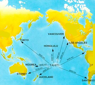
Located south of the Pacific Ocean, Tahiti is the largest island of French Polynesia. This beautiful island was formed by volcanic eruptions that took place more than 3 million years. This island is located in the archipelago of Society Islands and is part of the Windward Islands. Historically known as Otaheite, Tahiti is divided into 2 circles, the largest circle is known as Tahiti Nui, while the small circle is known as Tahiti Iti. Connected together by a thin narrow isthmus called Plateau Taravao, Tahiti Nui is said to be aged about 3 million years, while Tahiti Iti is said to be only a million years .
The island of Tahiti is about 45 km long at its widest point, Tahiti has a total area of 1045 km ² with lush mountainous terrain. There are four peaks on the island, the highest being Mount Orohena which stands on an impressive 7618 feet above sea level the summit of this mountain is usually shrouded in a veil of clouds. However, if you are lucky, on a clear day you can see the top of the summit.
The vast majority of the population lives on Tahiti Tahiti Nui, with a more rugged terrain. Most people live on the west coast of the island. The reason is that Papeete, the capital of French Polynesia and the largest city of Tahiti and is located on the northwest coast. With a well developed infrastructure of roads and highways, Tahiti Nui is an ideal place to explore the wildlife and culture of Tahiti.
On the other hand, Tahiti Iti Tahiti or small is less mountainous and more a place isolated from the rest of the island. Accessible only by boat or hiking, Tahiti Iti is rich in natural beauty with many picturesque coastal villages and scenic points on the landscape. It is a great place to escape the holiday crowds during the peak tourist season.
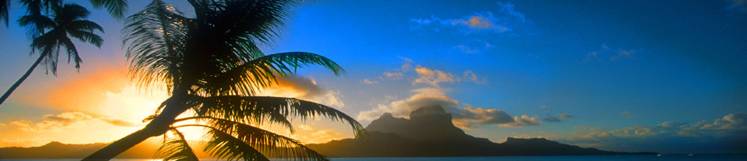
Covered by lush tropical forests, the interior areas of Tahiti are home to a wealth of beautiful trees, ferns and flowering plants with splashing waterfalls, rivers and deep valleys. The coastal areas of Tahiti are dotted with tall palm trees and fields of tropical flowers. The main crops include copra, vanilla, sugar cane and tropical fruits.
The black mountains and coral reefs around the lagoons showing the volcanic origin of Polynesia. The islands of Polynesia are the result of volcanic activity and track the movement of the Pacific plate that is moving north west while the "hot spot" remains fixed. Accordingly, the observed craters are only the remains of volcanic activity without being extinct volcanoes. Several islands are called atolls, as opposed to the islands, which are mountainous. The small size of land explains quite well that atolls are uninhabited and used only for fishing and pearl cultivation.
The high volcanic activity causes islands. Erosion and the stopping of any volcanic activity have consequences not only curbing the rise of islands, but their descent. The volcano threatens to become an atoll, which makes possible a day disappearance of Tahiti. Bora Bora could also suffer the same fate by becoming an atoll. This area includes several groups of islands and atolls including the largest and most populous east Tahiti. The beaches remain accessible at any time of day. Thanks to the purity of water that passes through a small ocean current, it is possible to culture pearls in deep waters on Polynesian atolls.